


MEPPERSHALL
Central Bedfordshire Council Local Plan - Call for Sites Consultation
Deadline date for responses is 17th August 2026
Sites proposed for development in Meppershall
Central Bedfordshire Council are consulting on 11 sites (see below map), covering 455 acres of countryside within Meppershall, for both residential and industrial development as part of their new Local Plan. This provides the potential to build between 5,460 to 13,650 new homes!
In the last 10 years Meppershall has seen significant levels of development, with sites continually being promoted for housing. If we don’t engage with consultations like this, there is a real risk that land could be identified for development without fully considering the impact on our village.
By responding, we can make the case for:
- Preserving Meppershall’s identity as a village.
- Protecting important green spaces and community facilities.
- Ensuring future growth is planned and sustainable.
- Making sure infrastructure is considered before development.
How to respond to the Call for Sites proposals in Meppershall online via CBC website
- Visit: https://centralbedfordshire.oc2.uk/document/99/9187#d9187
- Click on ‘Comment’ button under site 136293 – 7 Shefford Road.
- Click on ‘Create an Account’ and follow the on screen instructions. It is essential to create an account as CBC are only accepting online responses.
- Click ‘Support’ or ‘Object’ to development of site 136293.
- Type in your comments about the site or copy, paste and amend our responses as shown in the section below.
- Click ‘Submit’ to confirm your response.
- Click on ‘Comment’ button under site 136328 (next site in list) and repeat steps 4 to 6 above.
- Repeat for all Meppershall sites.
Note: There are some sites adjacent to our village boundary that will affect us. These sites are in Silsoe, Shillington and Gravenhurst. Please also consider providing comments to those sites (see sections below)
How to respond to the Call for Sites proposals in Meppershall via letter or email
UPDATE – Contrary to previous advice regarding the Central Bedfordshire Council call for sites consultation that comment could on by made via the online portal, they will now accept comments by email or letter.
Letters are to be addressed to:
Local Plans Team – Central Bedfordshire Council Priory House, Monks Walk, Chicksands, Shefford, Bedfordshire, SG17 5TQ
The Meppershall Neighbourhood Plan team are offering to deliver letters to CBC in bulk. Simply write your letter and post in the green letterbox at the end of Walnut Tree Way (near the High Street) by midnight on 16th August and they will collect and deliver in bulk.
Emails are to be sent to: localplan@centralbedfordshire.gov.uk
People are welcome to reference multiple sites in their letter / email comments if the issues/points they wish to raise are the same or they want to talk about cumulative impacts. There is no specific form for this but we have created a template letter with instructions for people to use if they want. You can download the letter here: CBC Call for Sites template letter
Map showing all sites proposed for development in Meppershall
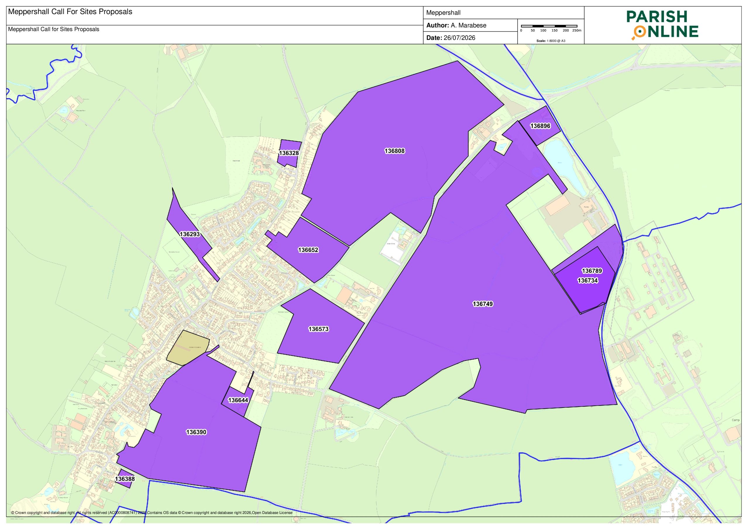
Please view, copy or amend our responses to create your own submissions. Simply click on the ‘V’ button to the right of each site description. If you prefer download a Word version here. Note: CBC have imposed a word limit of 100 words for all comment submissions.
Site 136293 - Land at and to the rear of 7 Shefford Road (Proposed use - Residential)
- Create permanent, urbanising encroachment beyond defined settlement envelope into rural, open countryside eroding the unsettled elevated village hilltop ridgeline, that would not respect, retain or enhance character, appearance and distinctiveness of local landscape character area.
- Remove Grade 2 BMV agricultural land
- Connect to foul drainage network with insufficient capacity
- Adversely affect elevated views from/to village across adjacent vales and intervening low ground
- Push building line beyond adjacent developments in East/West
- Harm landscape character and visual environment.
- Contradict the Landscape Strategy for the character area.
Contradicts Policies CBLP SP7, CC6, CC8, HQ1, EE5 and LCA guidelines. CBC previously refused.
MPC may look to support this site if:
- the line of development (building line) did not extend beyond adjacent development to the East/West.
- homes on the site are bungalows to the rear and no dwelling on site greater than 2 stories high.
- the green open space at the rear of the site extending along the village ridge line is transferred to the Parish Council creating a connected and extended green open space from Centenary Field to the rear of the Village Hall across to and including Woodlands Rest.
Site 136328 - Land between Shefford Road and Sandy View (Proposed use - Residential)
- Create significant built form/mass onto greenfield land outside settlement envelope at village edge.
- Alter visual impact/environment of transition from village to open countryside.
- Deviate from linear pattern of development along Shefford Road creating permanent/noticeable visual harm to landscape character.
- Fail to integrate with adjacent wooded area and rural context beyond.
- Not suitably conserve priority habitat forming deciduous woodland (site vegetation cleared) and harm biodiversity.
- Be unsustainable as distance from village amenities creates car dependency.
- Not connect to footpaths.
- Create highways safety issues as access on road bend.
Contradicts Policies SP7, EE2, EE4, EE5 and HQ1. PInspector previously dismissed.
Site 136388 - Stondon Road Glasshouses (Proposed use - Residential)
- Create highways safety issues as site entrance at narrow point in highway with no room for pedestrian link to Shillington Road/High Street.
- Create significant built form/mass outside settlement envelope at village edge.
- Be unsustainable as distance from village amenities creates reliance on cars.
- Alter visual impact/environment of transition from village to open countryside.
- Create overlooking and visibility of village as homes would be built on elevated ground due to site topology.
MPC may look to support this site if:
- Height of homes were limited so as not to create overlooking and alter the village skyline.
- As it would not be developing agricultural land but transform a brownfield site.
- Development and design were sympathetic to the adjacent conservation area.
Site 136390 - Land East of Coneygate stretching from Stondon Road to Fildyke Road (Proposed use - Residential)
- Remove Grade 3a BMV agricultural land
- Create significant built form/mass into area of countryside high ground outside settlement envelope.
- Alter visual impact/environment of transition from village to open countryside along Stondon Road.
- Adversely affect the beauty of the countryside elevated views from/to village across adjacent vales/intervening low ground (Stondon, valley and out towards Stevenage Hospital)
- Be detrimental/harm rural landscape setting/appearance of the village
- Deviate from linear pattern of development along High Street creating permanent/noticeable visual harm to landscape character.
- Create overlooking as built on elevated ground due to site topology.
- Destroy ancient lynchet/grass footpath running Northwest/Southeast across site
Contradicts Policies CBLP SP7, HQ1, HQ8, EE5 and EE4 and LCA guidelines and MNP RC1, NE1, H1, DND1, GSR3
Site 136573 - Land between Chapel Road, Hoo Road Bridleway and North of Fildyke Road (behind woodland) (Proposed use - Residential)
- Create significant built form/mass in countryside outside settlement envelope.
- Deviate from linear pattern of development along village roads.
- Harm/not respect, retain or enhance character, appearance and distinctiveness of the local landscape character area contrary to the Landscape Strategy
- Alter visual impact/environment of village/transition from village to countryside.
- Lack village highway links, creating isolated, car-dependent community.
- Access from rural Chapel Road, 60mph road with no footpath and lined with hedges/ditches.
- Cause harm to future residents’ living conditions via noise/disturbance from adjacent businesses.
- Enclose Old Road Meadow Nature Reserve harming wildlife, habitat and biodiversity, blocking green corridors/adding light pollution.
Site 136644 - Paddock and stables behind 70-80 Fildyke Road (Proposed use - Residential)
- Create significant backland development and built form/mass in countryside outside settlement envelope.
- Deviate from linear pattern of development along Fildyke Road creating permanent/visible harm to landscape character contrary to the Landscape Strategy.
- Alter visual impact/environment of village and transition from village to open countryside.
- Create severe highways safety, capacity, and logistical challenges, most notably severe congestion and deadlock, emergency service and waste vehicle restrictions, and pedestrian vulnerability as primary access is via single-vehicle track.
- Create highways safety issues as access on bend in road and no footpath for connectivity.
Site 136652 - Flints Field behind 40 Shefford Road (Proposed use - Residential, Stand-alone green spaces, Other)
- Create permanent, urbanising encroachment beyond defined north-easternmost extent of settlement envelope into rural, open countryside.
- Erode the unsettled elevated village hilltop ridgeline ribbon of development, rural identity, and local distinctive verdant character of the village and its setting
- Harm and not respect, retain or enhance character, appearance and distinctiveness of the local landscape character area contrary to the Landscape Strategy
- Create built mass down the unsettled slope towards the Hoo Road public bridleway.
- Be unsustainable as distance from village amenities creates car dependency.
Site previously refused at appeal APP/P0240/W/20/3249265
Site 136734 - ACO Site 1 (Proposed use - Employment)
- Strict caps on floodlights/security lights to prevent light pollution in dark rural skies that is already an issue from the site.
- Site layout/design sympathetic to open countryside around the site blends into the rural landscape/natural surroundings.
- Planting of local, native trees and hedgerows to screen buildings and site and blend it into the countryside.
- Effects on biodiversity are mitigated either on site or in village of Meppershall.
- Existing trees of importance at site entrance are protected and retained.
- Existing trees of importance at site entrance are protected and retained.
Site 136749 - Land between Hoo Farm, Chapel Farm and Stanpit House off A600 (Proposed use - Residential, Employment, Green Energy)
- Be a permanent, urban encroachment far beyond village settlement envelope into rural, open countryside.
- Be unsustainable and have no connectivity to the village creating an isolated, car-dependent community.
- Risk coalescence and erode rural distinctiveness of separation between villages of Meppershall, Shefford, Henlow and Stondon.
- Alter visual impact/environment of village and transition from village to open countryside.
- Lack of safe walking, cycling or public transport connections to facilities e.g.: schools, healthcare and shops.
MPC may consider supporting this site for green energy and employment if:
- Strict caps on floodlights/security lights to prevent light pollution in dark rural skies that is currently an issue.
- Site layout/design sympathetic to open countryside and current commercial site and blends into the rural landscape and natural surroundings.
- Planting of local, native trees and hedgerows to screen buildings and site and blend it into the countryside.
- Effects on biodiversity are mitigated either on site or in village of Meppershall.
Green energy is solar farm that has a direct benefit to the village. We object to a windfarm.
Site 136789 - ACO Site 2 (Proposed use - Employment)
- Strict caps on floodlights/security lights to prevent light pollution in dark rural skies that is already an issue from the site.
- Site layout/design sympathetic to open countryside around the site blends into the rural landscape/natural surroundings.
- Planting of local, native trees and hedgerows to screen buildings and site and blend it into the countryside.
- Effects on biodiversity are mitigated either on site or in village of Meppershall.
- Existing trees of importance at site entrance are protected and retained.
- Existing trees of importance at site entrance are protected and retained.
Site 136808 - Land between A507, Chapel Road and Shefford Road (Proposed Use - Residential, Employment, Green energy)
- Create permanent, urbanising encroachment beyond defined north-easternmost extent of settlement envelope into rural, open countryside.
- Erode the unsettled elevated village hilltop ridgeline ribbon of development, rural identity, and local distinctive verdant character of the village and its setting
- Harm and not respect, retain or enhance character, appearance and distinctiveness of the local landscape character area contrary to the Landscape Strategy
- Be unsustainable and have little connectivity to the village creating distant, isolated, car-dependent community.
- Risk coalescence and erode rural distinctiveness of separation between Meppershall and Shefford.
- Alter visual impact/environment of village and transition from village to open countryside.
Site 136896 - Airman site (Proposed Use - Residential)
- Be a permanent, urban encroachment far beyond village settlement envelope into rural, open countryside.
- Alter visual impact/environment of transition from village to open countryside.
- Be unsustainable and have little connectivity to the village creating distant, isolated, car-dependent community.
- Lack of safe walking, cycling or public transport connections to facilities e.g.: schools, healthcare and shops.
- Not suitably conserve priority habitat forming deciduous woodland (site cleared of vegetation) and harm biodiversity.
- Alter visual rural impact/environment of the Airman roundabout and surrounding area.
- Risk residential coalescence and erode rural distinctiveness of separation between Meppershall and Shefford.
The Parish Council comments on sites outside our boundary but that we believe will have an effect on us are currently being formulated and will be completed and uploaded to this page ASAP after consulting with neighbouring parishes. Please return to view, copy or amend our responses to create your own submissions.
Parish Council responses to sites in Henlow
To comment on this site go to https://centralbedfordshire.oc2.uk/document/99/9174#d9174 and click on the comment button under site 135347 (1st in list)
Residential development opposed:
- Removes Grade 2 BMV farmland.
- Creates urbanising encroachment beyond settlement envelope into rural, open countryside.
- Creates visible built mass in unsettle area. Screening development unachievable.
- Detrimental/harm rural identity, distinctive character of village, its setting/visual impact on wider rural landscape and views including PROW.
- Harms – doesn’t respect, retain/enhance character, appearance and distinctiveness of local landscape as development doesn’t extend southwards.
- Adversely affects beauty of the countryside – elevated views from/to village across intervening low ground.
- Additional traffic would impact local road capacity, worsen congestion/pedestrian and cyclist safety/noise/air quality.
- Unsustainable distance from amenities creates car dependency.
Would be in support of use of this site for employment use or green energy, or standalone green space.
Site 135351 – Land between Stanpit House, A600 and RAF Henlow (Proposed Use Employment)
To comment on this site go to https://centralbedfordshire.oc2.uk/document/99/9174#d9174 and click on the comment button under site 135351 (2nd in list)
Development would be supported for employment use:
- Established employment location with existing infrastructure.
- Supports economic growth plus job creation in the region.
- Efficient use of previously developed land – reducing pressure for development on greenfield site.
Parish Council responses to sites in Shefford
To comment on this site go to https://centralbedfordshire.oc2.uk/document/99/9196#d9196 and click on the comment button under site 136431 (4th in list)
MPC objection:
- Poor connectivity: 1.5km from the town centre, and 1.3km from the nearest bus stop, encouraging car dependency; contrary to NPPF sustainable development principles and Policy SP7.
- Site constraints: Sloping land and existing Hitchin Road drainage problems.
- Environment: Loss of Grade 1 Best and Most Versatile agricultural land, landscape/biodiversity impacts (Policy EE5) and risk of Shefford–Meppershall–Campton coalescence.
- Infrastructure: Additional traffic and A507 and A1(M) junction/roundabout congestion (Policies TP1/T2), air quality, water/wastewater capacity and Clifton WRC concerns.
- Previous assessment: Rejected at Stage 1B as poorly related to Shefford and detached from the settlement.
Site 136720 – Land between A507 and Hitchin Road (Proposed use – Employment, Green Energy)
To comment on this site go to https://centralbedfordshire.oc2.uk/document/99/9196#d9196 and click on the comment button under site 136720 (8th in list)
MPC Objection:
- Location: Outside Shefford’s settlement envelope and poorly related to the town; previously rejected at Stage 1B. Limited access to town centre, open space and public transport.
- Landscape/agriculture: Loss of Grade 1 BMV farmland and harm to countryside, wildlife and biodiversity, contrary to Policy EE5.
- Flood risk: Sloping land and drainage issues along Hitchin Road raise concerns.
- Highways/infrastructure: Construction traffic would worsen A507 congestion, safety, noise and air quality; concerns over water, wastewater and Clifton Water Recycling Centre capacity.
- Renewable energy/employment: Potentially acceptable subject to sensitive design, biodiversity measures, minimal lighting and compliance with EMP3, EMP4, EE13, HQ3, HQ4 and DC4.
Parish Council responses to sites in Clifton
To comment on this site go to https://centralbedfordshire.oc2.uk/document/99/9158#d9158 and click on the comment button under site 136727 (12th in list)
Site 136748 – Land between A507 and Hitchin Road (Proposed Use – Employment)
To comment on this site go to https://centralbedfordshire.oc2.uk/document/99/9158#d9158 and click on the comment button under site 136748 (13th in list)
Site 136828 – Land between A600 and A507 (Proposed Use – Employment and Green Energy)
To comment on this site go to https://centralbedfordshire.oc2.uk/document/99/9158#d9158 and click on the comment button under site 136828 (14th in list)
Site 136851 – Land between A600 and A507 up to New Road (Proposed Use)
To comment on this site go to https://centralbedfordshire.oc2.uk/document/99/9158#d9158 and click on the comment button under site 136851 (15th in list)
Parish Council responses to sites in Campton
To comment on this site go to https://centralbedfordshire.oc2.uk/document/99/9155#d9155 and click on the comment button under site 136747 (8th in list)
Meppershall Parish Council objection:
Development would:
- Creates permanent, urbanising encroachment beyond defined settlement envelope into rural, open countryside eroding the unsettled low valley and would not respect, retain or enhance character, appearance and distinctiveness of local landscape character area.
- Remove Grade 2 BMV agricultural land
- Connect to foul drainage network with insufficient capacity
- Adversely affect elevated views from/to villages across adjacent vales and intervening low ground
- Contradict the Landscape Strategy for the character area.
- Unsustainable site due to car dependency.
- Create coalescence of Campton and Shefford
Central Bedfordshire Local Plan – Background
Central Bedfordshire Council (CBC) has begun a consultation on the 452 potential housing sites across the local authority area, from which, in a couple of years, a shortlist will be agreed for development in the next Local Plan.
At the end of 2024, the council conducted a legal process known as a ‘Call for sites’ where anyone with land they want to develop, could put this forward. 626 sites were proposed. Council officers then worked through this list, removing 132 sites which were obvious candidates for refusal such as:
- Not big enough for at least 10 new homes.
- Land in SSSIs, or sites which are in the highest flood risk areas.
- Land with a legal issue e.g. submitted without permission of landowner.
- Sites not directly next to the edge of a town/village and not big enough to form a new settlement on their own.
CBC has now put together a website where you can see exactly where the remaining 452 sites are located sorted by village / town. You can also see how big each site is, what it could be used for. The council has received proposals of land amounting to about 10,900 hectares which we estimate would be enough for circa 381,500 houses – only about 7% of this land would be required. However, this is NOT a guarantee. On some land a developer may want to build mansions with huge gardens, on another they might want to build tower blocks. Plus, the rules over use of Green Belt sites are rightly stricter, so these are less likely to be used. This means areas without Green Belt will be more likely to be allocated housing than those who have it.
This consultation now offers everyone the opportunity to highlight which sites are the most unsuitable, so please get involved and have your say.
Frequently Asked Questions
- DO WE REALLY NEED MORE HOUSES IN THE COUNTRYSIDE? No one would disagree we need homes for the next generation. But what we don’t want, is to see our countryside and wildlife destroyed by ugly new housing developments or the look and feel of our village changed.
- WHAT HAPPENS IF CBC DOESN’T HAVE A LOCAL PLAN? The government insists councils have an up-to-date Local Plan, and CBC had one approved in 2021. If local authorities refuse, or drag their heels, developers can just apply to build wherever they want to, knowing even if the council turns it down, this could easily get overturned at appeal, as the local authority won’t be able to demonstrate they have a plan.
- HOW MANY HOUSES ARE NEEDED? The original proposal was 14,800 by 2045, but this has been increased to 25,500 by 2050. The government controls the numbers.
- IS CBC CONSULTING THE PUBLIC? Yes. All the way through the process they must consult with the public. All local authorities are obliged to provide housing as per government targets but the locations in question are down to local authorities (CBC) to decide. Under the current plan, CBC is obliged to find around 2,000 houses per year. This number only changes if the government decides it will. There are housing sites allocated until 2035. The new plan would extend this to 2050, so yes, there will be new houses allocated in Meppershall to cover the extra years.
- WHERE WILL THE HOUSES GO? This is to be decided by CBC officers with feedback from the current and future public consultation. It will depend to some extent on the land put forward.
- DOES THE COUNCIL CARE WHAT THE PUBLIC THINKS? They must consult. Housing will need to be allocated, we have no choice about that, but communities should be properly heard.
- WHAT ABOUT INFRASTRUCTURE? In the past, we have seen huge developments built, across the country, with little in the way of infrastructure. CBC says that the new Local Plan will better attempt to understand and enable delivery of what communities want alongside new homes.